US Topo Maps

Advertisement
1M+
Installs
ATLOGIS Geoinformatics GmbH & Co. KG
Developer
-
Productivity
Category
-
Rated for 3+
Content Rating
-
https://atlogis.com/privacy_policy.html
Privacy Policy
Advertisement
Screenshots
editor reviews
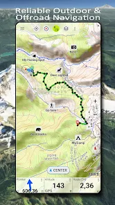
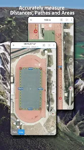
🗺️ Explore the great outdoors with US Topo Maps 🏞️, a comprehensive navigation tool for adventure-seekers and professional geographers alike! Developed by ATLOGIS Geoinformatics GmbH & Co. KG, this app stands out with its rich topographical content and precise GPS functionality. With an intuitive user interface, hikers, campers, and explorers can effortlessly access detailed maps 🌟, even in the most remote regions. The app's enviable database includes various map types from high-quality sources, ensuring that users receive the most reliable geographical information. Given the versatility and depth of its mapping capabilities, US Topo Maps naturally eclipses its competitors. Whether you need offline maps for a backcountry trek 🏕️ or updated aerial imagery for professional land surveying, this is your go-to digital guide. Discover why US Topo Maps is climbing the ranks in its category and become part of the community that navigates the wild with confidence. 🧭 Download the app now and venture into the unknown with a trusted map in your pocket! 📲
features
- 🔍 Detailed Topography - High-quality maps offer detailed elevation contours and terrain information.
- 🌐 Offline Mode - Access maps without an Internet connection, crucial for remote or rugged areas.
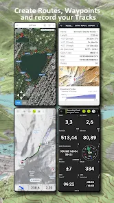
- 🎯 Accurate GPS - Pinpoint your exact location, track routes, and mark waypoints for easy navigation.
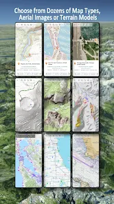
- 📊 Extensive Collection - A vast array of maps, including USGS topographic maps and satellite imagery.
- 🔄 Auto-Sync - Keep your data up-to-date across devices with automatic synchronization.
pros
- 🌟 Seamless User Experience - The intuitive interface makes navigating the app’s features a breeze.
- 🛰️ Aerial Imagery - Users can access updates satellite photos which aid in comprehensive visualization of the terrain.
- 🔒 Data Reliability - The information is sourced from authoritative and professional databases.
- 📌 Marking Tools - Integrated marking tools allow for personal annotations and route planning on-the-go.
cons
- 💾 Storage Space - High-detail maps can be storage intensive, needing adequate space on your device.
- 🎓 Learning Curve - New users may require time to fully utilize the app's extensive features and settings.
- ⚖️ Subscription Model - Access to some of the advanced features necessitates a paid subscription.
Advertisement
Recommended Apps
![]()
U Dictionary Translator
Talent Education Inc4.4![]()
Shudder: Horror & Thrillers
Digital Store LLC3.1![]()
Member Tools
The Church of Jesus Christ of Latter-day Saints4.2![]()
DIGI Clock Widget
ForestTree4.4![]()
Notisave
Tenqube Inc.4![]()
MTB Project
Adventure Projects4.3![]()
Popular Ringtones for Android
Ringtones and Notifications 2018 / 20194.3![]()
Future Self - Old Age Filter
Vidler Koiter1.6![]()
Remote for LG TV
AppAgency Labs4.3![]()
WiFi Map®: Internet, eSIM, VPN
WiFi Map LLC4.4![]()
Weather Forecast & Live Radar
Weather 365 Days0![]()
Phone Guardian VPN: Safe WiFi
data.ai Basics4.7![]()
QR code RW Scanner
Daniel Gtz4.3![]()
Reverse Phone Lookup Caller ID
TruthFinder4.4![]()
Spoon: Live Stream, Talk, Chat
Spoonradio.co3.7
You May Like
-
![]()
Holy Bible Offline
SOFTCRAFT4.6 -
![]()
Weather Forecast
Convenient & Easy Apps4.8 -
![]()
Da Fit
MO YOUNG LTD4 -
![]()
Okta Mobile
Okta Inc.3.2 -
![]()
Hallmark TV
Crown Media3 -
![]()
Joist App for Contractors
Joist Software Inc.4.4 -
![]()
Hims: Telehealth for Men
Hims & Hers4.7 -
![]()
Blackboard Learn
Anthology Inc.3.4 -
![]()
Neku: OC character creator
Sticker Maker Inc.4.5 -
![]()
Mercedes me (USA)
Mercedes-Benz USA, LLC3.5 -
![]()
Albertsons Deals & Delivery
Albertsons Companies, Inc.4.7 -
![]()
MyTherapy Pill Reminder
MyTherapy4.8 -
![]()
Sony | Music Center
Sony Corporation4.5 -
![]()
Bolt: Request a Ride
Bolt Technology4.8 -
![]()
Messages: Chat & Message App
Apps Specials4.2
Disclaimer
1.Apponbest does not represent any developer, nor is it the developer of any App or game.
2.Apponbest provide custom reviews of Apps written by our own reviewers, and detailed information of these Apps, such as developer contacts, ratings and screenshots.
3.All trademarks, registered trademarks, product names and company names or logos appearing on the site are the property of their respective owners.
4. Apponbest abides by the federal Digital Millennium Copyright Act (DMCA) by responding to notices of alleged infringement that complies with the DMCA and other applicable laws.
5.If you are the owner or copyright representative and want to delete your information, please contact us [email protected].
6.All the information on this website is strictly observed all the terms and conditions of Google Ads Advertising policies and Google Unwanted Software policy .

